
Page 39 - QUANGNINH ECONOMIC ZONE AUTHORITY
P. 39
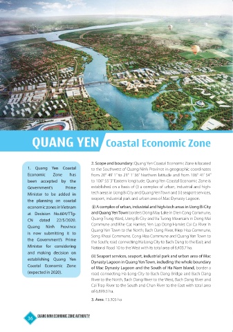
QUANG YEN                         Coastal Economic Zone


                                           2. Scope and boundary: Quang Yen Coastal Economic Zone is located
              1. Quang  Yen Coastal        to the Southwest of Quang Ninh Province in geographic coordinates
              Economic    Zone   has       from 20° 49’ 1” to 21° 1’ 36” Northern latitude and from 106° 41’ 54”
              been accepted by the         to 106° 55’ 3” Eastern longitude. Quang Yen Coastal Economic Zone is
              Government’s     Prime       established on a basis of (i) a complex of urban, industrial and high-
              Minister to be added in      tech areas in Uong Bi City and Quang Yen Town and (ii) seaport services,
              the planning on coastal      seaport, industrial park and urban area of Mac Dynasty Lagoon.
              economic zones in Vietnam     (i) A complex of urban, industrial and high-tech areas in Uong Bi City
              at  Decision  No.604/TTg-    and Quang Yen Town borders Dong May Lake in Dien Cong Commune,
              CN   dated   22/5/2020.      Quang Trung Ward, Uong Bi City and Vu Tuong Mountain in Dong Mai
              Quang   Ninh   Province      Commune and Khe Cat Hamlet, Yen Lap Dong Hamlet Cai Ca River in
              is now submitting it to      Quang Yen Town to the North; Bach Dang River, Hiep Hoa Commune,
                                           Song Khoai Commune, Cong Hoa Commune and Quang Yen Town to
              the Government’s Prime       the South; road connecting Ha Long City to Bach Dang to the East; and
              Minister for considering     National Road 10 to the West with its total area of 6,403.7 ha.
              and making decision on       (ii) Seaport services, seaport, industrial park and urban area of Mac
              establishing  Quang  Yen     Dynasty Lagoon in Quang Yen Town, including the whole boundary
              Coastal  Economic  Zone      of Mac Dynasty Lagoon and the South of Ha Nam Island, border a
              (expected in 2020).          road connecting Ha Long City to Bach Dang Bridge and Bach Dang
                                           River to the North, Bach Dang River to the West, Bach Dang River and
                                           Cai Trap River to the South and Chan River to the East with total area
                                           of 6,899.3 ha.

                                           3. Area: 13.303 ha


              36  Quang Ninh Economic Zone Authority